ALERT: Tropical Storm Harvey (August 24, 2017)
August 24, 2017
Tropical Storm Harvey is currently churning through the Gulf of Mexico.
Harvey is expected to become a hurricane by Friday, and the National Hurricane Center has issued a Hurricane Warning for parts of Texas.
Airlines have begun offering travel waivers, including: American Airlines, Delta Air Lines, and United Airlines.
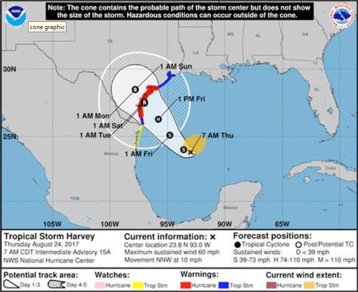
According to the National Hurricane Center:
SUMMARY OF WATCHES AND WARNINGS IN EFFECT:
A Hurricane Warning is in effect for…
* Port Mansfield to Matagorda Texas
A Hurricane Watch is in effect for…
* South of Port Mansfield Texas to the Mouth of the Rio Grande
A Tropical Storm Warning is in effect for…
* North of Matagorda to High Island Texas
* South of Port Mansfield Texas to the Mouth of the Rio Grande
A Tropical Storm Watch is effect for…
* South of the Mouth of the Rio Grande to Boca de Catan Mexico
A Storm Surge Warning is in effect for…
* Port Mansfield to San Luis Pass Texas
A Storm Surge Watch is in effect for…
* South of Port Mansfield Texas to the Mouth of the Rio Grande
* North of San Luis Pass to High Island Texas
DISCUSSION AND 48-HOUR OUTLOOK
——————————
Harvey is moving toward the north-northwest
near 10 mph (17 km/h). A track toward the northwest or
north-northwest at a faster forward speed is expected for the next
48 hours. On the forecast track, Harvey will approach the southern
Texas coast on Friday.
An Air Force Reserve aircraft reports that the maximum sustained
winds have increased to near 60 mph (95 km/h) with higher gusts.
Additional strengthening is forecast during the next 48 hours, and
Harvey is expected to become a hurricane by Friday.
Tropical-storm-force winds extend outward up to 115 miles (185 km)
from the center.
HAZARDS AFFECTING LAND
———————-
RAINFALL: Harvey is expected to produce total rain accumulations of
10 to 15 inches with isolated maximum amounts of 25 inches over the
Texas coast through next Wednesday. During the same time period
Harvey is expected to produce total rain accumulations of 3 to 9
inches along its outer radius including parts of south, central, and
eastern Texas and the lower Mississippi Valley. Rainfall from Harvey
may cause life-threatening flooding.
STORM SURGE: The combination of a dangerous storm surge and the
tide will cause normally dry areas near the coast to be flooded by
rising waters moving inland from the shoreline. The water is
expected to reach the following heights above ground if the peak
surge occurs at the time of high tide…
Port Mansfield to San Luis Pass…5 to 7 ft
San Luis Pass to High Island…2 to 4 ft
Mouth of the Rio Grande to Port Mansfield…2 to 4 ft Travel Leaders • 3033 Campus Drive Ste W320 • Plymouth, MN 55441
WIND: Hurricane conditions are likely within the hurricane warning
area late Friday or Friday night, with tropical storm conditions
expected to first reach the coast in the hurricane warning area
Friday.
Please contact the PR Team if you have any questions or concerns: TravelLeadersGroupPR@TravelLeaders.com.