ALERT: Puerto Rico- Hurricane Maria Makes “Life-threatening” Landfall as Category 4 (September 20, 2017)

 September 20, 2017

Hurricane Maria, now reduced to a Category 4 hurricane after battering the U.S. Virgin Islands as a Category 5 storm, has “lifethreatening” winds of 155 mph and flooding in Puerto Rico, according to the National Hurricane Center. Reports say Puerto Rico was hit with a force “not seen in modern history.” Maria has killed at least 7 people on the Caribbean island of Dominica.

Major airlines have travel waivers in place, including: American Airlines, Delta Air Lines and United Airlines.

According to the Telegraph:

Hurricane Maria is pummelling Puerto Rico, bringing “catastrophic” 155mph winds and dangerous storm surges, after battering the Virgin Islands.

The “monster” storm is one of the strongest to ever hit the US territory, with warnings that heavy rain could cause landslides and storm surges of up to 9ft that risk swamping low-lying areas.

Maria began lashing the US Virgin Island of St Croix early on Wednesday, as it continued to cut a deadly north-westerly path through the Caribbean.

According to CNN:

Hurricane Maria pummeled Puerto Rico on Wednesday morning, ripping trees out of the ground and hammering two-thirds of the island with hurricane-force winds.

“This is total devastation,” said Carlos Mercader, a spokesman for Puerto Rico’s governor. “Puerto Rico, in terms of the infrastructure, will not be the same. … This is something of historic proportions.”

Seven deaths on the Caribbean island nation of Dominica were blamed on the hurricane, said Gaston Browne, the Prime Minister of Antigua and Barbuda. Browne said he had been communicating with the Prime Minister of Dominica, Roosevelt Skerrit, whose own house was shredded by the storm.

Maria made landfall in Puerto Rico on Wednesday near the city of Yabucoa with winds of 155 mph, the National Hurricane Center said. By 10 a.m., those winds had weakened to 145 mph, but Maria was still a Category 4 hurricane capable of ripping roofs off houses.

The storm was so fierce, it broke two National Weather Service radars on the island.

According to the National Hurricane Center:

WATCHES AND WARNINGS

——————–

CHANGES WITH THIS ADVISORY:

The government of France has discontinued the Tropical Storm Warning

for St. Martin and St. Barthelemy.

The government of St. Maarten has discontinued the Tropical Storm

Warning and Hurricane Watch for St. Maarten.

The government of the Netherlands has discontinued the Tropical

Storm Warning for Saba.

SUMMARY OF WATCHES AND WARNINGS IN EFFECT:

A Hurricane Warning is in effect for…

* U.S. Virgin Islands

* British Virgin Islands

* Puerto Rico, Culebra, and Vieques

* Dominican Republic from Cabo Engano to Puerto Plata

* Turks and Caicos Islands and the Southeastern Bahamas

The NY Times reports:

Hurricane Maria made landfall on Puerto Rico as a powerful Category 4 storm early Wednesday, cutting electricity and phone lines, sending thousands of people into shelters and raising the prospect of deadly floods. The storm was bringing new misery to a region that has seen two other powerful hurricanes, Irma and Jose, in recent weeks.

As of 9 a.m., the eye of the storm was about 15 miles west-southwest of San Juan, having hit Yabucoa in the southeast shortly after 6 a.m. It had crossed the United States Virgin Islands as a Category 5 storm, then weakened slightly but remained “extremely dangerous,” with heavy rain and winds of up to 155 miles an hour.

As the hurricane moved in, residents across the island were awakened by the clamor of strengthening wind gusts.

“For Irma, we were very prepared,” Gov. Ricardo Rosselló said on CNN on Wednesday morning. “Unfortunately, of course, now we’re feeling a second storm in two weeks, and this one much more devastating than the first one. Who knows what the damage will be?”

Flooding and mudslides are major concerns, he warned, and the rain that follows the brunt of the storm could be just as dangerous as the winds.

Please contact the PR Team if you have any questions or concerns: TravelLeadersGroupPR@TravelLeaders.com.

 

ALERT: Hurricane Maria Intensifies- May Strike Puerto Rico and Virgin Islands (September 18, 2017)

September 18, 2017

Maria has rapidly intensified into a major Category 3 hurricane, with maximum sustained winds of 120 mph. This morning, the National Hurricane Center stated: “The eye is expected to move through the Leeward Islands late this afternoon or this evening.” It will likely strike the British and U.S. Virgin Islands and Puerto Rico by Wednesday.

Major airlines have travel waivers in place, including: American Airlines, Delta Air Lines and United Airlines. Many cruise lines are altering their itineraries, according to Cruise Critic.

According to the National Hurricane Center:

1. Maria will affect portions of the Leeward Islands and the British

and U.S. Virgin Islands as an extremely dangerous major hurricane

during the next couple of days, and hurricane warnings are in effect

for many of these islands.

2. Maria is likely to affect Puerto Rico as an extremely dangerous

major hurricane, and a hurricane watch is in effect for that island.

A hurricane warning will likely be issued later today.

3. The potential for a life-threatening storm surge, accompanied by

large and destructive waves, has increased for the Leeward Islands,

the Virgin Islands, and Puerto Rico.

4. Life-threatening flash floods and mudslides from heavy rainfall

are expected across the Leeward Islands, including Puerto Rico and

the U.S. and British Virgin Islands.

WATCHES AND WARNINGS

——————–

CHANGES WITH THIS ADVISORY:

A Hurricane Warning is now in effect for the U. S. Virgin Islands.

The Meteorological Service of Antigua has issued a Hurricane

Warning for the British Virgin Islands, and a Tropical Storm Warning

for Anguilla.

SUMMARY OF WATCHES AND WARNINGS IN EFFECT:

A Hurricane Warning is in effect for…

* Guadeloupe

* Dominica

* St. Kitts, Nevis, and Montserrat

* Martinique

* St. Lucia

* U.S. Virgin Islands

* British Virgin Islands

A Tropical Storm Warning is in effect for…

* Antigua and Barbuda

* Saba and St. Eustatius

* St. Maarten

* Anguilla

A Hurricane Watch is in effect for…

* Puerto Rico, Vieques, and Culebra

* Saba and St. Eustatius

* St. Maarten

* St. Martin and St. Barthelemy

* Anguilla

A Tropical Storm Watch is in effect for…

* Barbados

* St. Vincent and the Grenadines

CNN reports:

As feared, Hurricane Maria rapidly strengthened Monday as it took aim at Puerto Rico and islands left in ruins by Hurricane Irma.

Maria intensified to a Category 3 hurricane, hurling maximum sustained winds of 120 mph. The mammoth storm nearly doubled in strength over the past 24 hours and is expected to keep growing before it makes landfall.

As of 11 a.m. ET, Maria was centered about 60 miles (95 kilometers) east of Martinique. Its first landfall is expected around 8 p.m. ET in the northeast Caribbean’s Leeward Islands — specifically Dominica and Martinique.

And for the first time in 85 years, Puerto Rico is expected to suffer a direct landfall from a Category 4 hurricane. Puerto Rico’s governor has declared a state of emergency ahead of that landfall, which will likely happen Wednesday.

“It’s time to wrap up your preparations now, Puerto Rico,” CNN meteorologist Chad Myers said.

Please contact the PR Team if you have any questions or concerns: TravelLeadersGroupPR@TravelLeaders.com.
 

ALERT: London- Explosive device detonated on a London Underground (September 15, 2017)

September 15, 2017

An improvised explosive device was detonated on a London Underground train on Friday morning, injuring 22 people in what police say was a terrorist incident. No arrests have been made yet.

The New York Times reports:

LONDON Britain was hit by a terrorist attack on Friday morning, when a crude device exploded on a crowded London Underground train, injuring commuters, sowing panic, disrupting service and drawing a heavy response from armed police officers and emergency workers.

The device exploded at 8:20 a.m. on a District Line train leaving the Parsons Green station in Southwest London.

“This was a detonation of an improvised explosive device,” Assistant Commissioner Mark Rowley of the Metropolitan Police, a top counterterrorism official, said at a news conference. He urged anyone who had seen what happened, or had taken photos or videos of the bombing, to come forward.

The authorities immediately beefed up security around the transit system, as hundreds of police officers and detectives combed the scene for clues.

The Financial Times reports:

An improvised explosive device was detonated on a London Underground train on Friday morning, injuring 22 people in what police say was a terrorist incident. Counter-terrorism officers took charge of the investigation and were seeking to establish who had planted the device on a packed commuter train during rush hour. Armed police and emergency services rushed to Parsons Green Underground station in west London after receiving reports of an explosion at 8.20am.

The device comprised a bucket in a carrier bag with protruding wires, according to witness accounts and images on social media. Passengers on the District Line train said it burst into flames, leaving those nearest to it with burns.

Theresa May has called a meeting of the emergency Cobra committee to discuss the event. “My thoughts are with those injured at Parsons Green and emergency services who are responding bravely to this terrorist incident,” the prime minister said.

The Washington Post reports:

WASHINGTON – President Donald Trump weighed in Friday on an attack in London by a “loser terrorist” and used the episode to call for an expansion of his travel ban that has temporarily blocked entry into the United States by citizens of six Muslim-majority countries.

The travel ban into the United States should be far larger, tougher and more specific-but stupidly, that would not be politically correct!” the president wrote on Twitter.

Please contact the PR Team if you have any questions or concerns: TravelLeadersGroupPR@TravelLeaders.com.


ALERT: Hurricane Irma- Airlines Prep for Shutdown (September 8, 2017)


September 8, 2017


Hurricane Irma’s impending landfall in Florida is forcing airlines serving some of the largest airports in Florida to shutter operations for the weekend. Commercial flights will cease at Key West Airport at 8 p.m. on Friday and Orlando International Airport at 5 p.m. on Saturday and at Fort Lauderdale at 7:45 p.m. American Airlines, Delta and United Air Lines have each issued travel advisories or waivers for individuals with tickets to or from certain cities the region.


MoneyCNN reports:

By late Saturday, Miami, Orlando and Fort Lauderdale – home to the 12th, 13th, 21st largest airports in the U.S., respectively – will be largely dormant as the extreme weather rolls in.

But the prospect of a direct hit from Irma represents another blow to U.S. air travel in one of the busiest air corridors on the planet for business and leisure travel.

Among Miami, Fort Lauderdale and Orlando, the three airports handled more than 115 million passengers in 2016.

The scramble was so acute that the Federal Aviation Administration on Thursday evening said air traffic controllers were increasing the space between flights from Miami and nearby Fort Lauderdale to enable them to better manage the crowded skies. And American Airlines (AAL) was briefly under an FAA ground stop in Miami due to ATC rerouting outbound aircraft.

The airline had added 16 extra flights from Miami on Thursday, including 12 to Dallas, one to Philadelphia and three to New York, enough room for more than 3,600 passengers. The Fort Worth-based carrier said it has canceled more than 2,400 flights as of Thursday afternoon stretching through Sept. 11.

The biggest single carrier in the Miami-Fort Lauderdale region is American, which accounts of 38% of the flying there, according to Morgan Stanley. Southwest Airlines (LUV) is the largest single operator in Orlando at 20%.

Delta Air Lines (DAL), too, has added 2,000 additional seats on Thursday flights out of Florida and Caribbean islands, including the Bahamas, Dominican Republic and Jamaica, including 1,500 from Fort Lauderdale and Miami.

Airlines and airports operate preparedness plans in 72, 48 and 24 hour markers, evacuating aircraft and personnel and preparing stations as part of a methodical checklist ahead of a storm’s arrival, according to Ken Jenkins, principal crisis response strategist at NavAid Crisis Consulting Group.

Commercial flights will cease at Key West Airport at 8 p.m. on Friday and Orlando International Airport at 5 p.m. on Saturday due to Hurricane Irma and Fort Lauderdale at 7:45 p.m. In Orlando, 50 knot winds will shut down the airport’s outdoor tram which shuttles passengers between terminals.

The duration of any shutdown remains uncertain. American said any timeline for resumption of flights will be governed by not only airport conditions, but also the ability of airport and airline staff to get to work.

It’s not just commercial airlines getting out of Irma’s path.

Farther north in South Carolina, Boeing (BA) said it was suspending manufacturing operations starting on Saturday morning. The company’s expansive North Charleston facility is flying out any 787 Dreamliner that’s able to fly or bringing aircraft inside the factory, which is rated for a category five hurricane.

Residents were told to evacuate with a tsunami alert issued for the region and neighbouring countries.

Please contact the PR Team if you have any questions or concerns: TravelLeadersGroupPR@TravelLeaders.com.

ALERT: Tsunami Warning for Pacific Coast of Mexico After Earthquake (September 8, 2017)

September 8, 2017

A tsunami “threat” was issued by the U.S. Tsunami Warning System off the coast of Chiapas, Mexico after the most powerful earthquake to hit Mexico in a 100 years was reported off the Pacific coast of Mexico, leaving at least 29 people dead. At this time, the major U.S. airlines have not issued travel waivers for this area.

The San Jose Mercury News reports:

The U.S. Tsunami Warning System said hazardous tsunami waves were possible on the Pacific coasts of several Central American countries. Waves were possible within the next three hours for Mexico, Guatemala, El Salvador, Costa Rica, Nicaragua, Panama, Honduras and Ecuador, it said. There was no tsunami threat for the U.S. West Coast.

CNN reports:

At least 29 people have died after the most powerful earthquake to hit Mexico in a century struck off the country’s southern coast.

The magnitude-8.1 quake, which was felt as far as Mexico City and Guatemala City, was registered off Mexico’s southern coast just as heavy rains from Hurricane Katia lashed the east. The epicenter was in the Pacific Ocean, some 600 miles (1,000 kilometers) southeast of the capital and 74 miles (120 kilometers) from the Pacific coast.

Mexican President Enrique Peña Nieto said the quake was the strongest earthquake Mexico has experienced in 100 years.

It hit just before midnight on Thursday, when many people would have been sleeping.

Alejandro Murat, the governor of Oaxaca, told CNN that 23 people were killed in his state alone. Four others have died in Chiapas state and two in Tabasco.

The Travel Weekly UK reports:

The magnitude 8.2 quake struck about 62 miles south-west of the town of Pijijiapan just after midnight on Thursday local time.

The quake was reportedly felt in Mexico City, with buildings shaking and people running into the street.

Residents were told to evacuate with a tsunami alert issued for the region and neighbouring countries.

Please contact the PR Team if you have any questions or concerns: TravelLeadersGroupPR@TravelLeaders.com.


ALERT: Hurricane Irma (Updated-September 7, 2017)

September 7, 2017

Irma is still a Category 5 hurricane with maximum sustained winds of 180 mph. Reports state it has maintained intensity above 180 mph longer than any storm in Atlantic basin history.

This morning, the National Hurricane Center stated: “The eye of Irma should continue to move just north of the coast of Hispaniola today, be near the Turks and Caicos and southeastern Bahamas by this

evening, and then be near the Central Bahamas by Friday..”

Florida, Georgia, North Carolina and South Carolina have all declared states of emergency, and mandatory evacuations took place in the Florida Keys and were set to begin today in the Miami area.

According to The Weather Channel:

Miami-Dade County ordered its first mandatory evacuation in 12 years Wednesday. The order goes into effect at 9 a.m. Thursday.

About 420,000 people living in Miami Evacuation Zones A and B along the coast are expected to be told to flee. The last time a similar evacuation was ordered was for Hurricane Wilma in 2005.

[In the Florida Keys], mandatory evacuations have been ordered for both visitors and residents ahead of the storm. An estimated 25,000 or more left the area, causing bumper-to-bumper traffic on the single highway linking the islands to the mainland.

The New York Times reports:

Hurricane Irma, one of the strongest ever recorded in the Atlantic, made direct hits on Barbuda, St. Barthélemy, St. Martin, Anguilla and the British Virgin Islands, and raked the United States Virgin Islands and Puerto Rico.

The death toll from the storm stood at 11 on Thursday morning, but the authorities warned that it would rise as communications improved.

Nearly 70 percent of households in Puerto Rico were without power after hurricane-force winds and torrential rain. Almost 50,000 people were without water, according to the territory’s emergency management agency.

The Category 5 hurricane, which by 5 a.m. Thursday had slowed to 180 miles per hour from 185, left Barbuda in shambles, damaging 95 percent of its buildings and leaving the island “barely habitable.”

Major airlines have travel waivers in place, including: American Airlines, Delta Air Lines and United Airlines. Many cruise lines are also impacted, read more here.

According to the National Hurricane Center:

SUMMARY OF WATCHES AND WARNINGS IN EFFECT:

A Hurricane Warning is in effect for…

* Dominican Republic from Cabo Engano to the northern border with

Haiti

* Haiti from the northern border with the Dominican Republic to Le

Mole St. Nicholas

* Southeastern Bahamas and the Turks and Caicos Islands

* Central Bahamas

* Northwestern Bahamas

A Hurricane Watch is in effect for…

* Cuba from Matanzas province eastward to Guantanamo province

A Tropical Storm Warning is in effect for…

* Dominican Republic from south of Cabo Engano westward to the

southern border with Haiti

* Haiti from south of Le Mole St. Nicholas to Port-Au-Prince

* Cuba provinces of Guantanamo, Holguin, and Las Tunas

Interests elsewhere in the Dominican Republic and Haiti, as well as

Cuba and Florida should monitor the progress of Irma. A Hurricane

Watch will likely be issued later this morning for portions of

southern Florida and the Florida Keys.

For storm information specific to your area, please monitor products

issued by your national meteorological service.

DISCUSSION AND 48-HOUR OUTLOOK

——————————

At 800 AM AST (1200 UTC), the eye of Hurricane Irma was located

near latitude 20.1 North, longitude 69.0 West. Irma is moving

toward the west-northwest near 17 mph (28 km/h), and this general

motion is expected to continue with some decrease in forward speed

for the next couple of days. On the forecast track, the eye of Irma

should continue to move just north of the coast of Hispaniola today,

be near the Turks and Caicos and southeastern Bahamas by this

evening, and then be near the Central Bahamas by Friday.

Maximum sustained winds remain near 180 mph (285 km/h) with

higher gusts. Irma is a category 5 hurricane on the Saffir-Simpson

Hurricane Wind Scale. Some fluctuations in intensity are likely

during the next day or two, but Irma is forecast to remain a

powerful category 4 or 5 hurricane during the next couple of days.

HAZARDS AFFECTING LAND

———————-

STORM SURGE: The combination of a life-threatening storm surge and

large breaking waves will raise water levels ABOVE NORMAL TIDE

LEVELS by the following amounts within the hurricane warning area

near and to the north of the center of Irma. Near the coast, the

surge will be accompanied by large and destructive waves.

Turks and Caicos Islands…15 to 20 ft

Southeastern and central Bahamas…15 to 20 ft

Northwestern Bahamas…4 to 7 ft

Northern coast of the Dominican Republic…3 to 5 ft

Northern coast of Haiti and the Gulf of Gonave…1 to 3 ft

Northern coast of Cuba in the warning area…5 to 10 ft

Water levels around Puerto Rico should subside today.

WIND: Hurricane conditions are expected to begin within the

hurricane warning area in the Dominican Republic and Haiti today,

with tropical storm conditions beginning in the next few hours.

Hurricane conditions are expected to begin in the warning area in

the southeastern Bahamas and the Turks and Caicos Islands later

today with tropical storm conditions expected within the next

several hours. These conditions will spread into the Central

Bahamas by tonight or early Friday.

Hurricane and tropical storm conditions are possible within the

watch area in Cuba by Friday. Tropical storm conditions are

expected to begin within the warning area in Cuba tonight. Hurricane

conditions are expected in the northwestern Bahamas Friday night and

Saturday.

RAINFALL: Irma is expected to produce the following rain

accumulations through Saturday:

Northeast Puerto Rico and the British and U.S. Virgin Islands…An

additional 2 to 4 inches.

Much of the Bahamas and the Turks and Caicos…8 to 12 inches,

isolated 20 inches.

Northern Dominican Republic and northern Haiti…4 to 10 inches,

isolated 15 inches.

Eastern and Central Cuba…4 to 10 inches, isolated 15 inches.

Southern Haiti…1 to 4 inches.

In all areas this rainfall may cause life-threatening flash floods

and mudslides.

SURF: Swells generated by Irma are affecting the northern Leeward

Islands, Puerto Rico, the Virgin Islands, the southeastern Bahamas,

the Turks and Caicos Islands, the northern coast of the Dominican

Republic, and they should start affecting portions of the southeast

coast of the United States later today and tonight. These swells

are likely to cause life-threatening surf and rip current

conditions. Please consult products from your local weather office.

Please contact the PR Team if you have any questions or concerns: TravelLeadersGroupPR@TravelLeaders.com.


ALERT: Hurricane Irma (September 6, 2017)

September 6, 2017

Hurricane Irma continues to barrel through the Caribbean with maximum sustained winds of 185 mph. It is being called one of the most powerful Atlantic storms in a century.

This morning, the National Hurricane Center stated: “The extremely dangerous core of Irma will move over portions of the northern Virgin Islands today, pass near or just north of Puerto Rico this afternoon or tonight, and pass near or just north of the coast of the Dominican Republic Thursday.”

Major airlines have travel waivers in place, including: American Airlines, Delta Air Lines and United Airlines. Many cruise lines are also impacted.

USA Today reports:

Carnival and Disney Cruise Line late Tuesday joined Royal Caribbean and Norwegian Cruise Line in cancelling upcoming sailings out of Florida … Vessels heading back to Florida ports ahead of schedule include Norwegian Sky, Norwegian Escape, Disney Fantasy and Disney Dream.

More than half a dozen other Florida-based ships are operating drastically modified itineraries this week to avoid the storm, with many switching from Eastern Caribbean to Western Caribbean routes.

According to the National Hurricane Center: Travel Leaders • 3033 Campus Drive Ste W320 • Plymouth, MN 55441

SUMMARY OF WATCHES AND WARNINGS IN EFFECT:

A Hurricane Warning is in effect for…

* Antigua, Barbuda, Anguilla, Montserrat, St. Kitts, and Nevis

* Saba, St. Eustatius, and Sint Maarten

* Saint Martin and Saint Barthelemy

* British Virgin Islands

* U.S. Virgin Islands

* Puerto Rico, Vieques, and Culebra Travel Leaders • 3033 Campus Drive Ste W320 • Plymouth, MN 55441

* Dominican Republic from Cabo Engano to the northern border with

Haiti

* Guadeloupe

* Southeastern Bahamas and the Turks and Caicos Islands

A Hurricane Watch is in effect for…

* Haiti from the northern border with the Dominican Republic to Le

Mole St. Nicholas

* Turks and Caicos Islands

* Southeastern Bahamas

* Cuba from Matanzas province eastward to Guantanamo province

* Central Bahamas

A Tropical Storm Warning is in effect for…

* Dominican Republic from south of Cabo Engano westward to the

southern border with Haiti

A Tropical Storm Watch is in effect for…

* Haiti from south of Le Mole St. Nicholas to Port-Au-Prince

Interests elsewhere in the Dominican Republic and Haiti, as

well as Cuba, the northwestern Bahamas, and Florida should monitor

the progress of Irma.

DISCUSSION AND 48-HOUR OUTLOOK

——————————

At 800 AM AST (1200 UTC), the eye of Hurricane Irma was located near

latitude 18.1 North, longitude 63.3 West. Irma is moving toward the

west-northwest near 16 mph (26 km/h), and this general motion is

expected to continue for the next couple of days. On the forecast

track, the extremely dangerous core of Irma will move over portions

of the northern Virgin Islands today, pass near or just north of

Puerto Rico this afternoon or tonight, and pass near or just north

of the coast of the Dominican Republic Thursday.

Maximum sustained winds remain near 185 mph (295 km/h) with higher

gusts. Irma is a category 5 hurricane on the Saffir-Simpson

Hurricane Wind Scale. Some fluctuations in intensity are likely

during the next day or two, but Irma is forecast to remain a

powerful category 4 or 5 hurricane during the next couple of days.

Hurricane-force winds extend outward up to 50 miles (85 km) from

the center and tropical-storm-force winds extend outward up to 175

miles (280 km). A wind gust to 90 mph (146 km/h) was recently on

the island of St. Eustatius located south of the eye of Irma. A

NOAA National Ocean Service station on Barbuda reported sustained

winds of 118 mph (190 km/h) with a gust to 155 mph (249 km/h)

before the instrument failed earlier this morning.

HAZARDS AFFECTING LAND

———————-

STORM SURGE: The combination of a life-threatening storm surge and

large breaking waves will raise water levels ABOVE NORMAL TIDE

LEVELS by the following amounts within the hurricane warning area Travel Leaders • 3033 Campus Drive Ste W320 • Plymouth, MN 55441

near and to the north of the center of Irma. Near the coast, the

surge will be accompanied by large and destructive waves.

Northern Leeward Islands…7 to 11 ft

Turks and Caicos Islands…15 to 20 ft

Southeastern Bahamas…15 to 20 ft

Northern coast of the Dominican Republic…3 to 5 ft

Northern coast of Haiti and the Gulf of Gonave…1 to 3 ft

The combination of a life-threatening storm surge and the tide will

cause normally dry areas near the coast to be flooded by rising

waters moving inland from the shoreline. The water is expected to

reach the following HEIGHTS ABOVE GROUND if the peak surge occurs at

the time of high tide…

British and U.S. Virgin Islands except St. Croix…7 to 11 ft

Northern coast of Puerto Rico…3 to 5 ft

Southern coast of Puerto Rico and St. Croix…1 to 2 ft

WIND: Hurricane conditions will continue today within the

hurricane warning area in the Leeward Islands. Hurricane

conditions are expected to begin within the British and U.S. Virgin

Islands this morning and spread westward over portions of Puerto

Rico later today. Hurricane conditions are expected to begin within

the hurricane warning area in the Dominican Republic early Thursday,

with tropical storm conditions beginning tonight. Hurricane

conditions are expected in the warning area in the southeastern

Bahamas and the Turks and Caicos Islands beginning Thursday night.

Hurricane and tropical storm conditions are possible within the

watch area in Haiti by early Thursday and in the central Bahamas

and Cuba by Friday.

RAINFALL: Irma is expected to produce the following rain

accumulations through Thursday:

Northern Leeward Islands…8 to 12 inches, isolated 20 inches

Northeast Puerto Rico and the British and U.S. Virgin Islands…4 to

10 inches, isolated 15 inches Southwest Puerto Rico, the southern

Leeward Islands, and Saint Croix…2 to 4 inches

Irma is expected to produce the following rain accumulations

Wednesday through Saturday:

Southeast Bahamas, the Turks and Caicos and eastern to central

Cuba…8 to 12 inches, isolated 20 inches

Northern Dominican Republic and northern Haiti…4 to 10 inches,

isolated 15 inches

Southwest Haiti…1 to 4 inches

In all areas this rainfall may cause life-threatening flash floods

and mudslides.

SURF: Swells generated by Irma will affect the northern Leeward

Islands, Puerto Rico, the Virgin Islands, the southeastern Bahamas,

the Turks and Caicos Islands, the northern coast of the Dominican

Republic, and portions of the southeast coast of the United States

during the next several days. These swells are likely to cause

life-threatening surf and rip current conditions. Please consult

products from your local weather office.

Please contact the PR Team if you have any questions or concerns: TravelLeadersGroupPR@TravelLeaders.com.

ALERT: Japan Airlines Plane Makes Emergency Landing (September 5, 2017)

September 5, 2017

A Japan Airlines flight from Tokyo to New York made an emergency landing at Haneda International Airport on Tuesday. The cause is pending, but has been alleged to be a bird strike during takeoff. No injuries were reported.

The Japan Times reports:

A total of 251 passengers and crew members were aboard the plane, but no one was injured.

The operator of the Boeing 777 first suspected a bird strike, but the ministry later said there was no sign that birds had been hit by the aircraft.

JAL Flight 6 took off from Haneda airport at 11 a.m., heading in a northerly direction. An onboard alarm indicated trouble with the left engine shortly afterward and the aircraft notified air traffic control.

After the pilots shut down the left engine, the plane returned to Haneda and landed at 12:09 p.m.

After the landing, the transport ministry’s office at the airport confirmed via a monitor that flames were coming from the plane’s left engine and noticed smoke rising from grass near the northern edge of the runway. The runway was closed and shattered aircraft parts were later found there.

According to the International Business Times:

Video footage broadcast by Japan’s public broadcaster NHK News showed red flames flickering from the left engine of the Boeing 777 as the aircraft ascended from the runway. 

According to Japan’s Ministry of Land, Infrastructure, Transport and Tourism official, a grass field near one of the runways caught fire for a brief period after the JAL plane departed, but it was doused immediately.

Passengers on board heaved a sigh of relief as they landed safely.

“Right after taking off, we heard five bangs and the plane shook,” a 57-year-old passenger told NHK after landing. “But all the passengers were calm.”

Haneda, one of the world’s busiest airports, is reported to be the worst for bird strikes in Japan.

There were apparently 182 cases of bird strikes last year, which was followed by Osaka airport with 73 cases and Narita at 57, according to Japan’s Asahi Shimbun newspaper.

Please contact the PR Team if you have any questions or concerns: TravelLeadersGroupPR@TravelLeaders.com.


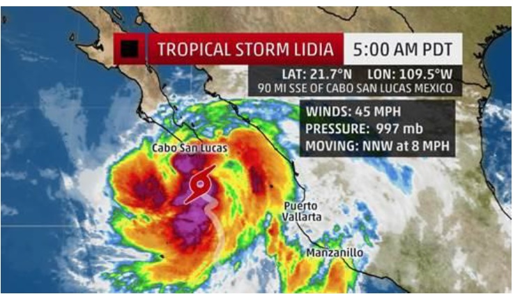
ALERT: Mexico- Tropical Storm Lidia (August 31, 2017)

August 31, 2017

A storm off the coast of Mexico has now gained enough strength to become Tropical Storm Lidia.

According to the National Hurricane Center, its “Moving toward the Baja California peninsula [and] conditions will deteriorate across southern Baja California Sur through the day.”

Cabo San Lucas is in the path of the storm and major airlines are offering travel waivers including: American Airlines, Delta Air Lines, and United Airlines.


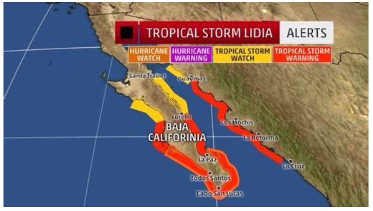
NHC: SUMMARY OF WATCHES AND WARNINGS IN EFFECT:

A Hurricane Watch is in effect for…

* Baja California Sur from Puerto Cortes to east of La Paz

A Tropical Storm Warning is in effect for…

* Baja California Sur from Puerto San Andresito to Loreto

* mainland Mexico from Bahia Tempehuaya to Guaymas

A Tropical Storm Watch is in effect for…

* Baja California Sur north of Puerto San Andresito to Punta

Abreojos

* Baja California Sur north of Loreto to Bahia San Juan Bautista

* mainland Mexico north of Guaymas to Bahia Kino

DISCUSSION AND 48-HOUR OUTLOOK

—————————— Travel Leaders • 3033 Campus Drive Ste W320 • Plymouth, MN 55441

On the forecast track, the center of Lidia will be near the southern tip of the Baja California peninsula this afternoon, and it will move over the peninsula Friday and Friday night.

Maximum sustained winds are near 45 mph (75 km/h) with higher

gusts. Strengthening is forecast before Lidia’s center reaches the

Baja California peninsula.

Tropical-storm-force winds extend outward up to 160 miles (260 km)

to the east of the center.

HAZARDS AFFECTING LAND

———————-

RAINFALL: Lidia is expected to produce total rain accumulations of

8 to 12 inches across the Mexican states of Baja California Sur and

western Jalisco, with isolated maximum totals of 20 inches. In the

Mexican states of Sinaloa, Nayarit, Colima, southern Michoacan,

southern Sonora, and central Jalisco, rainfall amounts of 3 to 6

inches are expected. These rains are expected to cause

life-threatening flash floods and mudslides.

WIND: Tropical storm conditions are expected to first reach the

coast within the warning area in Baja California Sur later this

morning, making outside preparations difficult or dangerous.

Hurricane conditions are possible within the hurricane watch area

late today. Tropical storm conditions are expected in the warning

area in mainland Mexico starting later today or tonight. Tropical

storm conditions are possible in the watch areas late Friday.

Please contact the PR Team if you have any questions or concerns: TravelLeadersGroupPR@TravelLeaders.com.


LERT: Houston Airports Reopen (August 31, 2017)

August 31, 2017

Houston’s two major airports, George Bush Intercontinental Airport and William P Hobby Airport, have reopened. Flights continue to be limited as Hurricane Harvey recovery continues and major airlines are still offering travel waivers, including: American Airlines, Delta Air Lines, and United Airlines.

According to The Houston Chronicle:

Houston’s airports began trudging back into operation Wednesday, with the first commercial traffic in three days offering a faint symbol of recovery from the devastation of Hurricane Harvey.

United Airlines and Delta Air Lines started service and others are expected to soon follow suit. But so far, it’s just a trickle. United, which has a major hub at George Bush Intercontinental Airport, is initially scheduling three daily arrivals and three departures. On a typical day, 480 United flights take off.

USA Today reports:

Nationwide, more than 1,400 flights were grounded for Thursday, according to flight-tracking service FlightAware. Another 1,120 had already been preemptively canceled on Friday with 42 more already scrubbed from Saturday’s schedules. Nearly all of those came on flights to or from Houston.

During a span stretching back to Friday, when Harvey first began affecting flights, more than 10,600 airline flights have been canceled most because of Harvey. Of that total, more than 9,000 cancellations have come from the two Houston airports alone, according to FlightAware.

Please contact the PR Team if you have any questions or concerns: TravelLeadersGroupPR@TravelLeaders.com.


Page 5 of 26« First...34567...1020...Last »